167 commits | Last commit ≈ 19 months ago
Ctrl K
TRIDEC Cloud
TRIDEC Cloud serves functionality to handle and share threat specific information. It integrates services for obtaining event related geo-data, e.g. of earthquakes, for automated computations, e.g. of tsunami propagations, for mapping, summarizing, and communicating hazard specific data.
What TRIDEC Cloud can do for you
TRIDEC Cloud & GeoPeril (Discontinued)
In times of cloud computing and ubiquitous computing the use of state of the art technology concepts and paradigms have to be considered even for early warning and fast response systems. Based on the experiences and the knowledge gained in three research projects state-of-the-art technologies have been used to implement a cloud-based and web-based platform to open up new prospects for tsunami early warning and mitigation systems (TEWS).
TRIDEC Cloud merged several complementary external and in-house cloud-based services into one platform for automated background computation with graphics processing units (GPU), for web-mapping of hazard specific geospatial data, and for serving relevant functionality to handle, share, and communicate threat specific information in a collaborative and distributed environment.
GeoPeril has been the framework of TRIDEC Cloud. This implementation of an early warning system for tsunamis included, among other things, the harvesting of earthquake events from catalogs or APIs, the automatic execution of simulations for events with given thresholds, remote execution of simulations with EasyWave or Tsunami-HySEA and the modifying of earthquake parameters or creating fictional earthquakes to simulate a scenario.
User group
The platform was meant for researchers and authorities around the world to make use of cloud-based GPU computation, to analyze tsunamigenic events, and react upon the computed situation picture with a web-based GUI in a web browser at remote sites. Features
- Global coverage, and applicable for any region in the world
- Workflow implemented following operators’ or users’ needs, even in stressful situation
- Integrated threat management & tracing of information, activities, and sequences related to an event
- Integration of different observational networks and services
- Integration of different computation engines, i.e. simulation software and hardware (CPU, GPU)
- Provision of different input data for computations, e.g. different resolutions
- Generation of pre-defined, internationally agreed messages with dynamic content provided by observations and computations
- Dissemination via E-mail, Fax, FTP/GTS, SMS, Cloud Messages, Shared Maps
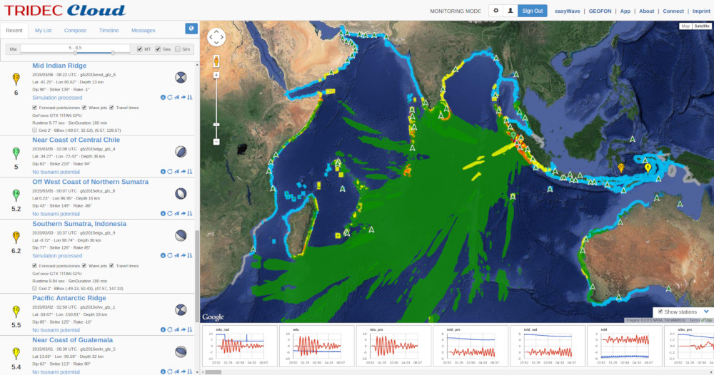 Using TRIDEC Cloud to monitor possible tsunamis (early warning).
The monitoring mode listed the latest and past earthquake events with information on magnitude, location, time, and depth, as well as dip, strike, and rake. An earthquake classification was provided based on a simplified decision matrix and a tsunami prediction was available for critically classified earthquakes based on an attached simulation either computed automatically or manually in the background. Information on earthquakes have been complemented by historic and real-time sea level data. The map displayed the position of the sea level stations. Small diagrams below the map displayed the measurements for each sea level station.
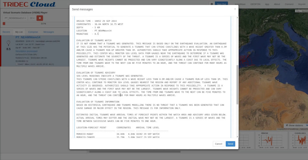 Sending information about a tsunami with TRIDEC Cloud.
Interactive diagrams allowed a detailed analysis and picking of values that are available for automated integration in warning messages. The generation of warning messages was based on internationally agreed message structures and included static and dynamic information based on earthquake information, instant computations of tsunami simulations, and actual measurements. Automatically generated messages were served for review, modification, and dissemination.
The exercise and training mode enabled training and exercises with virtual scenarios. This mode disconnected real world systems and connected with a virtual environment that receives virtual earthquake information and virtual sea level data re-played by a scenario player. The exercise and training mode has been used in an opportunity provided by the international NEAMWave14 tsunami exercise to test the TRIDEC Cloud as a collaborative activity based on previous partnerships and commitments at the European scale (Hammitzsch et al. 2014). For the NEAMWave21 exercise the modelling of the KOERI-NOA scenario had been done by KOERI through the easyWave tsunami modelling tool embedded in the TRIDEC Cloud. During the conduct of the NEAMWave21 exercise, TRIDEC Cloud was also utilized by KOERI for the real-time simulation of the sea-level readings.

Keywords
early warning
Earth & Environment
GPU
impact analysis
SaaS
scenario computation
simulation system
tsunami
virtual scenario training
Programming languages
- Other 2%
License
- Apache-2.0
</>Source code